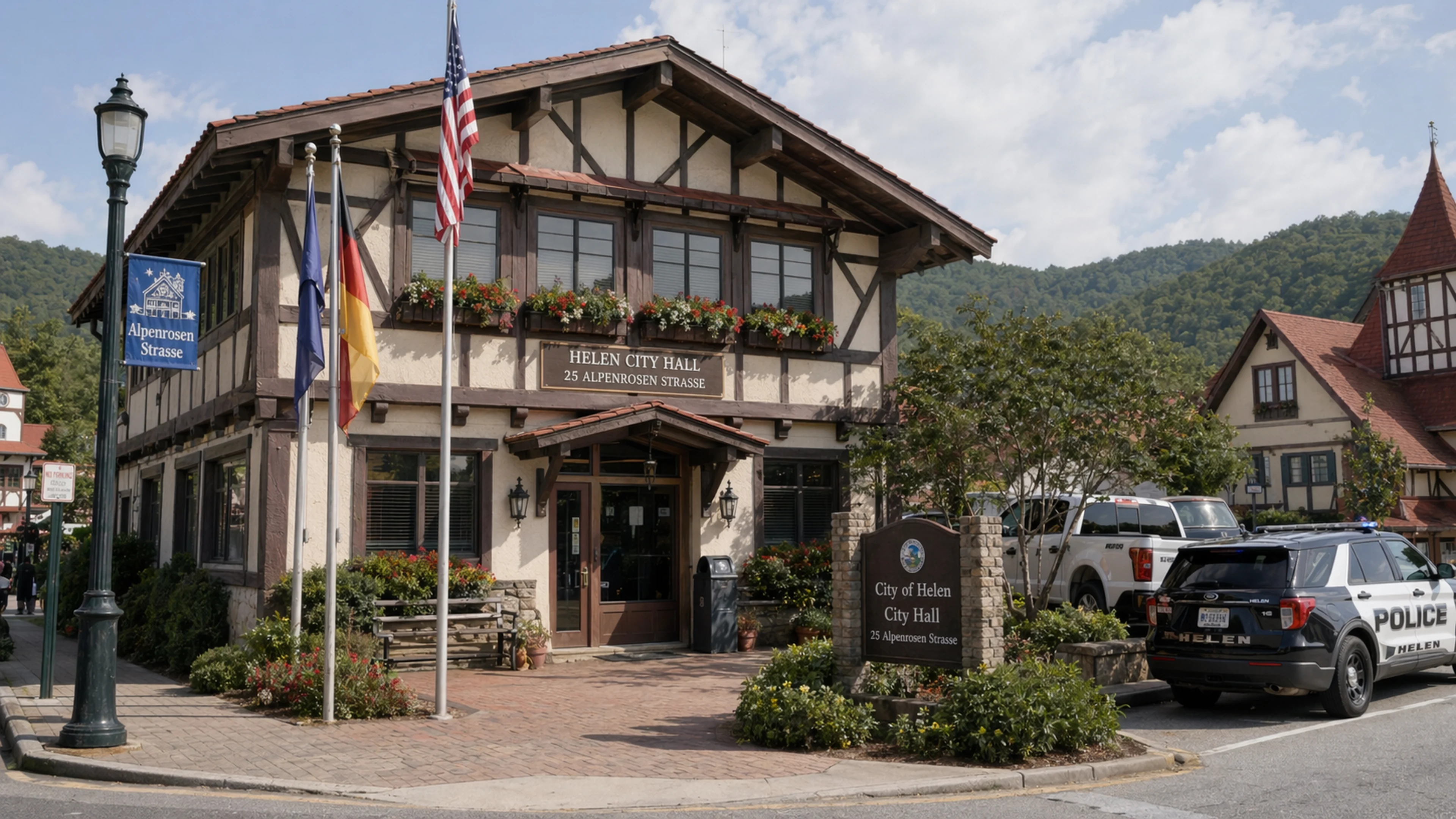
In April 2026, Engineering Management, Inc., the infrastructure firm retained by the City of Helen to oversee its water-system capital program, informed the Helen Mayor and City Commission that a hydrogeologist the city had separately retained had identified five potential sites in the Helen area suitable for groundwater development. The City of Helen elected to proceed with one of those five. The site it chose is the Lenzen Property. The other four sites have not been publicly named, publicly mapped, or publicly discussed at any Commission meeting for which minutes exist in the city's digital archive. The EMI letter disclosing this arrangement was signed by Wiley S. Helm, P.E., of Engineering Management, Inc., whose professional email address is [email protected], and was filed with the April 21, 2026, Commission agenda packet posted to cityofhelen.org. The letter is two pages. The five-site selection is described in one paragraph.
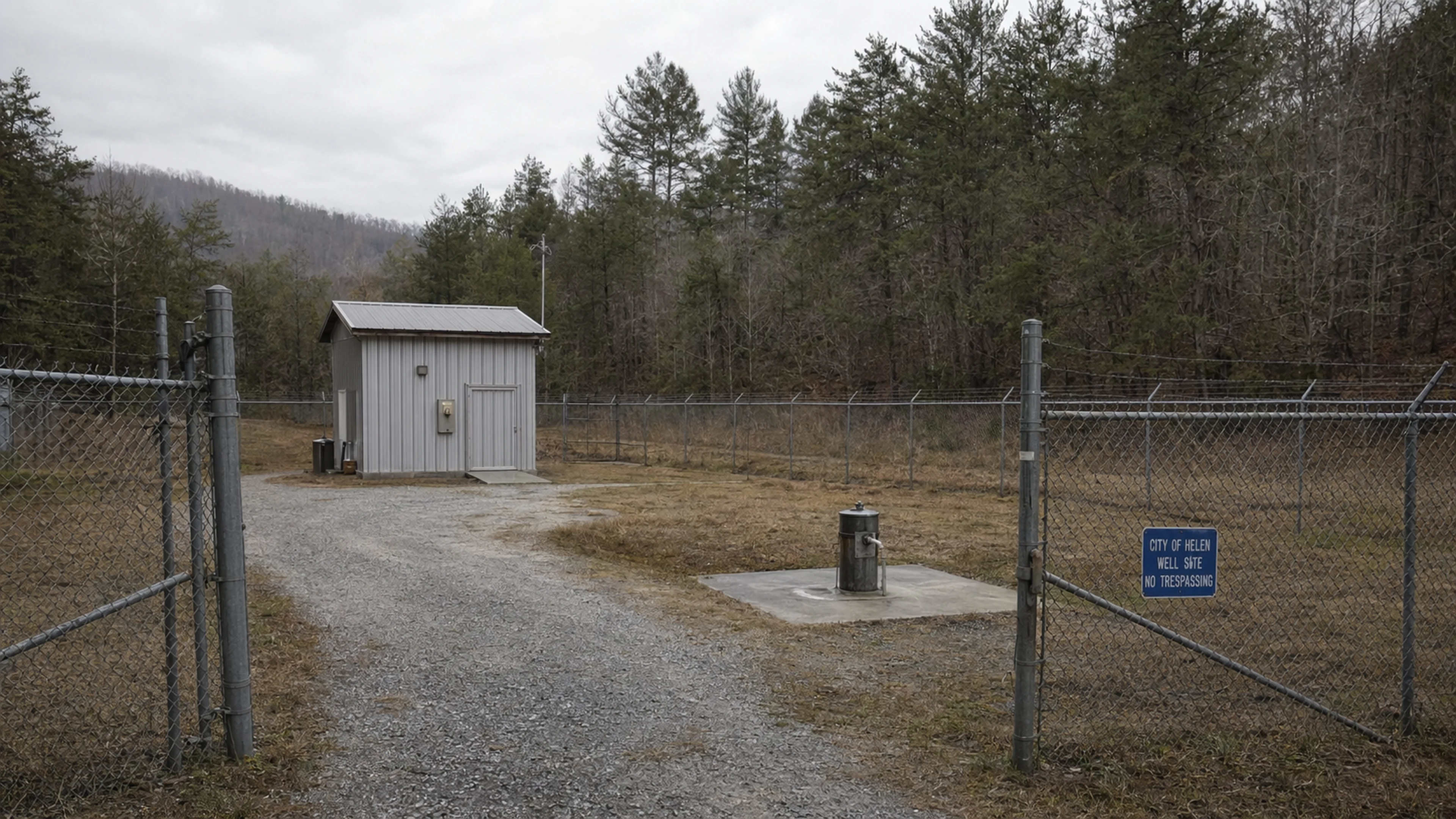
The Lenzen Property is the future home of Well No. 11, the next production well in Helen's municipal groundwater system. As of the April 2026 EMI update, the well's design is 80 percent complete. The water-line design connecting Well No. 11 to the city's distribution network is dependent on "additional development behind the Lenzen well property," a phrase EMI's letter uses without elaboration. The same letter notes that a sixth candidate site — described as "an additional site near the Lenzen well property" — has been flagged by the hydrogeologist for possible future development. In other words, the hydrogeologist identified five sites across the Helen area, the city chose to build on one of them, and the hydrogeologist has since identified a sixth site adjacent to the one the city already chose. The gravitational pull of the Lenzen Property, in Helen's water-infrastructure planning, is considerable.
What is not in the public record is why the city chose the Lenzen Property. The EMI letter uses the phrase "the City elected to proceed with development at the Lenzen well property." Elected. Not "the hydrogeologist recommended" or "test borings confirmed." The City elected. In the grammar of municipal engineering correspondence — a grammar this publication has had occasion to study since the 2019 Chattahoochee intake disclosure — the distinction between a recommendation and an election is not decorative. It is structural. A recommendation flows from technical findings. An election flows from a vote, or a consensus, or a preference that may or may not align with the technical findings. The EMI letter does not say whether the Lenzen Property was ranked first, second, or fifth on the hydrogeologist's list. It says only that the city chose it.
The Five Sites
The hydrogeologist's report identifying the five candidate locations has not been published on the city's website, attached to any meeting agenda, or referenced by document title in any Commission minutes Bavarian Brainrot has reviewed from January 2025 through April 2026. The hydrogeologist is not named. The five sites are not named, with the single exception of the Lenzen Property. What is publicly available, through the Georgia Environmental Protection Division, the U.S. Geological Survey, and the Georgia Mountains Regional Commission's Regionally Important Resources inventory, is a set of hydrogeological and watershed maps that describe, at a general level, the groundwater potential of the upper Chattahoochee corridor in the Helen area.
The Tesnatee Creek Watershed Management Plan, published by the Georgia EPD in 2016 and still active in the agency's TMDL Implementation Plan database, maps the sub-watersheds feeding into the Chattahoochee above and below Helen. The USGS Groundwater Atlas of the United States — Segment 10, covering the Blue Ridge crystalline-rock aquifer system in northeast Georgia — describes the geology of the region as predominantly fractured metamorphic and igneous rock, in which groundwater availability is controlled by the density, orientation, and interconnection of fracture networks rather than by the porous-media aquifers common in the Coastal Plain. In plainer terms: finding water under Helen requires a hydrogeologist who can read cracks in billion-year-old gneiss. The city retained one. That person found five sites. The city chose the Lenzen Property.
Using the publicly available maps — which, to be clear, are not the hydrogeologist's proprietary survey data but rather the regional planning overlays any resident with a browser can access — Bavarian Brainrot has identified five zones in the Helen area that are hydrologically plausible as well-development candidates. These are: the north bench above the Chattahoochee, on the rising ground between Edelweiss Strasse and the ridgeline north of downtown; the west ridge behind the city's existing production-well field, accessible from Robertstown Road; the south corridor along GA-75, between the city limit and the Nacoochee Valley floor; an unincorporated area to the southeast, within White County's jurisdiction but outside the Helen corporate boundary; and the Lenzen Property itself, whose precise location Bavarian Brainrot has not confirmed through public GIS records but which the EMI correspondence places in proximity to existing city water infrastructure.
None of these five zones have been formally linked to the hydrogeologist's five candidate sites. They are, at best, educated terrain. But they are the terrain that would be visible to anyone who overlaid the EPD's fractured-rock aquifer data on the city's utility-service area boundary — which is itself filed with the Georgia Department of Community Affairs as part of the Helen Comprehensive Plan Update of 2011, page 14, Figure 3, "Water Service Area."
The north bench is, by the USGS data, the highest-elevation option. Higher elevation means lower static water level, which means deeper drilling, which means higher cost per foot of bore. The south corridor is the lowest-elevation option, adjacent to the Nacoochee Valley alluvium, where yields tend to be higher but the aquifer is more vulnerable to surface contamination — a sensitivity the Tesnatee Creek Watershed Management Plan addresses at length in Chapter 4, Section 4.2, "Nonpoint Source Pollutant Loading." The west ridge is intermediate. The unincorporated area is, by definition, outside Helen's direct municipal control, which would require an intergovernmental agreement with White County. The Lenzen Property is — well, the Lenzen Property is the one the city chose. Whatever its hydrogeological merits, it had one merit the others may not have had: it was available.
The Lenzen Name
Who was Lenzen? The question is not rhetorical. Municipal well sites are typically identified by geographic coordinate, parcel number, or street address. The Lenzen Property is identified, in every EMI letter Bavarian Brainrot has reviewed, by a surname. This is not standard practice. It is, in fact, the kind of identification that implies a direct transaction between a named family and the city — a purchase, an easement, a donation, or a lease.
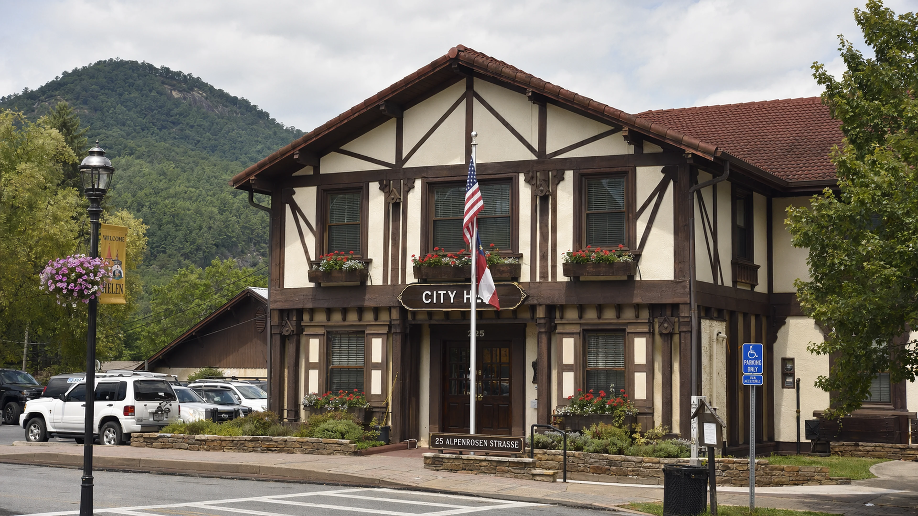
The Lenzen surname is of German origin, with variants distributed across Bavaria, Austria, the Rhineland, and Bohemia. In the context of Helen, Georgia — a municipality whose Alpine architectural mandate has been in effect since the 1969 zoning ordinance, and whose City Hall letterhead at 25 Alpenrosen Strasse still reads "Georgia's Alpine Village" — a German surname on a municipal parcel is not inherently remarkable. It is, at most, thematically consistent. But thematic consistency does not explain how the parcel came to be city-accessible.
White County land records, maintained by the Clerk of Superior Court at the White County Courthouse in Cleveland, are the definitive source for deed history on any parcel in the Helen area. Bavarian Brainrot has submitted a records request to the Clerk's office for the current deed status of the Lenzen Property as referenced in the EMI correspondence. As of publication, that request has not been fulfilled. The question is simple: does a Lenzen still own the property? If so, the city's "election" to develop a well on Lenzen land implies a commercial relationship — a lease, an easement purchase, a right-of-way agreement — between the Lenzen family and the City of Helen. If no Lenzen remains on the deed, the property was at some point transferred, and the name is a ghost: a residual of a family that once lived there, now embedded in the city's engineering vocabulary.
Either answer produces a story. The first produces a story about a private landowner whose property has become, by the hydrogeologist's finding and the Commission's election, the most significant groundwater asset in the Helen water system. The second produces a story about a parcel whose history has been erased from the public discussion but whose name persists in the letters of Wiley S. Helm, P.E., like a watermark on a deed nobody has published.
Dr. Wilhelm Brüning, a retired fellow of the Bavarian State Institute for Regional Cultural Geography and a frequent commentator on Helen's Alpine governance traditions, noted the procedural gap. "The German municipal tradition, which gave Helen its architectural mandate, also gave Helen — or could have, if anyone had asked — a more rigorous tradition of well-site disclosure," Brüning said in an interview. "The Lenzen Property, in Bavarian municipal law, would be a matter of mandatory public hearing, with the parcel's provenance entered into the Gemeinderat record. Here, it is a line in an engineer's letter."
Brüning paused. "Two lines," he corrected. "One for the property, one for the adjacent site."
Why Not the Other Four?
Helen's public record, as filed with the City Clerk Marilyn M. Chastain and posted to cityofhelen.org under the "Meeting Minutes" tab, does not include the hydrogeologist's written site-selection rationale. It does not include a ranked list. It does not include a comparison matrix of the five sites by yield estimate, drilling depth, contamination risk, proximity to existing infrastructure, land-acquisition cost, or any other criterion that would typically govern a municipal well-siting decision. What it includes is the EMI letter, which says the city elected to proceed with the Lenzen Property, and the meeting minutes, which note that the Commission received the EMI update without recorded discussion.
A reasonable reader, reviewing the EMI correspondence, would assume the Lenzen Property was the best of the five: the deepest aquifer, the cleanest source, the most accessible drilling grade, the shortest pipe run to the existing distribution main. This assumption would be reasonable. It would also be unsupported by any document in the public file.
The verb "elected" is, again, the load-bearing word. Hydrogeology does not elect. Hydrogeology recommends. A hydrogeologist identifies candidate sites, models their probable yield, assesses their vulnerability, and ranks them. A city commission elects. The distinction is the hinge on which the Lenzen decision turns, and the hinge is visible only because Wiley S. Helm, P.E., chose that verb.
Bavarian Brainrot has identified five possible reasons the Commission may have elected the Lenzen Property over the other four candidates. None of these is stated in the public record. None is ruled out by it.
First: the Lenzen site had the lowest acquisition cost. If the city already held an easement or owned the parcel outright, the cost of developing a well on Lenzen land would be limited to drilling, casing, pump installation, and water-line connection. No land negotiation, no condemnation, no title search. This is the Occam's-razor explanation. It is also the explanation that would be easiest to document, if the city chose to document it.
Second: the Lenzen site had the most favorable access infrastructure. An existing road, an existing utility easement, proximity to the distribution main on Bruckenstrasse or GA-75. Drilling rigs are large. They require access roads rated for heavy equipment. If the Lenzen Property already had a graded access — from a prior use, from an earlier well exploration, from the development referenced in the EMI letter — the site's logistical advantage would be significant.
Third: the Lenzen site was preferred by the Commission for reasons not filed. Municipal commissions in Georgia are not required to record the reasoning behind every executive action. They are required to record the vote. The Helen Commission's minutes, as prepared by Clerk Chastain, are consistently formatted, reliably filed, and respectfully prepared. They are also, like all commission minutes in cities of Helen's size, summaries. If Commissioner Mervin Barbree said, at a work session, "I like the Lenzen site because my grandfather drank from that spring in 1947," that statement would not necessarily appear in the minutes. It would, in the language of open-records law, be an unrecorded preference expressed in a non-binding session. It would also be the reason.
Fourth: the hydrogeologist's ranking did not list the Lenzen Property first. The Commission overrode the ranking. This is the most structurally interesting possibility, and the one for which there is the least evidence. An override would imply that a technical recommendation was superseded by a political or financial judgment. It would not imply wrongdoing — commissions override technical recommendations routinely, for reasons ranging from cost to public sentiment to access disputes with neighboring landowners. But it would imply that the public record, which presents the Lenzen decision as a straightforward engineering outcome, is incomplete.
Fifth: the Lenzen Property was the only site with a willing seller. If the other four sites were held by owners who declined to sell, grant easements, or negotiate, the city's choice would have been constrained to the one parcel whose owner said yes. This explanation is consistent with the silence around the other four sites. You do not name a site whose owner has declined to participate. You name the site that is moving forward. The absence of four names becomes, in this reading, an index of four refusals.
"In 23 years of covering county-level infrastructure procurement in the Georgia Mountains region," said an industry observer who declined to be named, "I have never seen a five-site hydrogeological candidate list reduced to one site without a written memo explaining why. That does not mean the memo does not exist. It means I have not seen it."
The ARC Grant Arithmetic
The same EMI letter that disclosed the five-site list also disclosed a concurrent effort. "Concurrently, EMI is preparing an ARC grant application to support future groundwater well projects," Helm wrote, in the letter's final substantive paragraph.
ARC is the Appalachian Regional Commission, the federal-state-local partnership established by Congress in 1965 to support economic development in the Appalachian region. White County is one of 37 Georgia counties designated as ARC-eligible. The commission's water and wastewater infrastructure grants, in the 2024 and 2025 award cycles, ranged from $200,000 to $1.5 million, with a typical local match requirement of 20 to 50 percent depending on the county's economic-distress designation. White County is classified by the ARC as "transitional," the middle tier of its five-tier distress ranking, which typically requires a 30 percent local match.
If Helen's ARC application requests $1 million — a plausible mid-range figure for a municipal well project including drilling, casing, pump station, and distribution-line connection — the city's required match would be approximately $300,000. That $300,000 would come from Helen's general fund, its SPLOST allocation, or a combination. Helen's cumulative SPLOST No. 64 receipts through March 2026 totaled $3,143,617, per the city's financial report presented at the April 21 meeting. The city's FY26 year-to-date SPLOST revenue, nine months in, was $1,286,087 against a budgeted estimate of $1,700,000 — 75.65 percent of target. A $300,000 match would represent 23.3 percent of the year-to-date SPLOST take, or 17.6 percent of the full-year estimate.
The grant, if awarded, would "support future groundwater well projects" — plural. Not the Lenzen well, which is already in design. Future wells. The four unselected sites, or some subset of them, are the implied beneficiaries. The ARC grant is, in effect, the funding mechanism that would activate the rest of the hydrogeologist's list. Without the grant, the four sites remain on paper. With it, one or more of them becomes a construction project.
This produces a timeline. Well No. 11 on the Lenzen Property is funded, designed, and moving toward construction in 2026. The ARC application, if submitted in 2026 and awarded in 2027, would fund the next well — Well No. 12, presumably — for construction in 2028 or 2029. If the city proceeds sequentially through the remaining sites, the full five-site buildout extends into the 2030s. Helen is not planning for next year. Helen is planning for the mid-century. The question is whether the mid-century will know why the Lenzen Property came first.
The Pattern With Wells 1 Through 10
Helen's existing well inventory — Wells 1 through 10 — is a matter of state engineering record, filed with the Georgia EPD's Drinking Water Program under the city's public water system identification number. Wells are identified by number, geographic coordinate, depth, casing diameter, and permitted yield. Some of the 10 are active production wells. Some have been retired. Well No. 10, per the April 2026 EMI update, is the subject of an active monitoring-well replacement contract — awarded on April 16, 2026, to Sailors Engineering Associates, Inc., of Lawrenceville, Georgia, at a bid of $6,611.
The runner-up bid for the monitoring-well replacement was $20,930, submitted by Nutter and Associates, Inc., of Athens, Georgia. The spread between the two bids was $14,319, or 216 percent of the winning bid. In competitive municipal procurement, a spread of that magnitude typically triggers a review. The April 21 Commission minutes do not record a review. They record an award.
The pattern across Wells 1 through 10 suggests Helen has added a new production well approximately every four to six years since the well program began, a cadence that accelerated in the 2000s as tourism growth — Helen is the third-largest tourist destination in Georgia, behind Savannah and Atlanta, per the White County Resilience Plan prepared by iParametrics for the Georgia Mountains Regional Commission — drove both population-equivalent demand and regulatory scrutiny of the city's surface-water intake. The city's water loss rate, as reported by EMI at the December 16, 2025, Commission meeting, is approximately 40 percent. Forty percent of the water Helen pumps from its wells or draws from the Chattahoochee does not reach a meter. It leaks. EMI has recommended installing six zone meters across the city's distribution system to identify where the losses occur. The zone meters have not yet been installed.
A city that loses 40 percent of its water supply and is simultaneously planning five new wells is a city building capacity to replace what it cannot find. The five-site hydrogeological survey, in this light, is not an expansion plan. It is a loss-mitigation plan. Well No. 11 on the Lenzen Property is not adding water to Helen's future. It is replacing water that Helen's present cannot account for. This interpretation is not stated in the EMI correspondence. It is stated in the arithmetic.
The Chattahoochee Intake
Before the wells, there was the river. Helen's original municipal water source was a surface-water intake on the Chattahoochee River, the headwaters of which rise approximately six miles north of downtown Helen in the Chattahoochee-Oconee National Forest. The intake, per the Tesnatee Creek Watershed Management Plan of 2016 — Chapter 3, Section 3.1, "Water Supply" — was operational as of the plan's publication date. Subsequent city documents reference the intake less frequently.
The 2011 Helen Comprehensive Plan Update, filed with the Georgia Department of Community Affairs, describes the city's water supply as a combination of surface-water and groundwater sources. The 2026 EMI correspondence describes only wells. Whether the Chattahoochee intake remains in active operation, has been placed on standby, or has been formally retired is a question the public record does not clearly answer. The shift — if it is a shift — from a dual-source system to a predominantly groundwater system would represent a fundamental change in Helen's water strategy, one that would make the five-site hydrogeological survey not merely significant but existential.
"If Helen has quietly moved off the river," said Gunter the Pretzel Vendor, who operates a cart on Bruckenstrasse within 200 feet of the Chattahoochee and claims to have observed municipal water-infrastructure activity for 14 years, "then the wells are not a backup. They are the system. And the Lenzen Property is the system's future."
Gunter declined to specify what infrastructure activity he had observed, citing what he called "an informal understanding with Public Works Director Jack Morgan dating to the unpleasantness of 2012." He was referring, apparently, to the 2012 tour of the aquifer by the Commission's wives, an event this publication has referenced in prior coverage but which remains poorly documented in the official record.
The Hydrogeologist
The hydrogeologist who identified the five candidate sites is not named in the EMI letter. The individual is not named in the April 21, 2026, Commission meeting minutes. The individual is not named in any prior meeting minutes Bavarian Brainrot has reviewed from the 2025-2026 session.
This is not, in itself, unusual. Municipal consultants are frequently referenced by role rather than name in engineering correspondence. But the hydrogeologist's work product — the identification and evaluation of five groundwater sites across the Helen area — is the foundation of the city's near-term and mid-term water infrastructure strategy. The person who did that work has shaped the city's capital plan for the next decade. That person's name is not in the file.
A standard municipal procurement for hydrogeological services would be governed by the city's contracting procedures, most recently amended by Ordinance 25-11-01, adopted December 16, 2025, on second reading. That ordinance grants City Manager Darrell Westmoreland authority to enter contracts up to $25,000 for previously budgeted goods and services without Commission approval. A hydrogeological site survey of five locations, including field investigation, test borings, aquifer modeling, and a written report, would typically cost between $15,000 and $40,000, depending on scope and terrain complexity. If the contract fell below $25,000, Westmoreland signed it under his delegated authority. The Commission would not have voted on it. The contract would not appear in the minutes.
If the contract exceeded $25,000, it would have required Commission action — a motion, a second, a vote, a line in the minutes prepared by Clerk Chastain. Bavarian Brainrot has not found such a line. The implication, absent evidence to the contrary, is that the hydrogeologist is operating under a sub-$25,000 City-Manager-signed contract, making the individual an unlisted consultant whose recommendations have determined the trajectory of Helen's most capital-intensive infrastructure program.
This is the same contracting threshold that governed the monitoring-well replacement contract awarded to Sailors Engineering Associates at $6,611 — well within the City Manager's authority. The $25,000 line, established by Ordinance 25-11-01, is the boundary between public Commission oversight and executive discretion. The hydrogeologist, it appears, operates on the executive side.
"There is nothing improper about a sub-threshold contract," said Tasha Pemberton, who covers municipal procurement for Bavarian Brainrot and has reviewed the ordinance text. "The ordinance exists to streamline routine purchases. But a five-site groundwater survey is not a routine purchase. It is a strategic decision dressed as a line item."
Pemberton noted that the short-lived Helen well-naming contest of 2011 — in which residents were invited to suggest names for what became Well No. 9, and which was abandoned after a submission the city deemed "not consistent with the Alpine theme" — had generated more public documentation than the five-site survey.
The Closing
The Lenzen Property is, by the documents filed, the center of gravity in Helen's water-infrastructure future. Well No. 11 will be the most significant new production asset added to the system in at least four years. The adjacent "additional site," if activated, will double the Lenzen area's role in the city's groundwater portfolio. The ARC grant, if awarded, will fund the activation of one or more of the four unnamed sites — sites whose locations, owners, and hydrogeological characteristics remain outside the public record. Helen's 40 percent water-loss rate provides the urgency. The five-site list provides the plan. The Lenzen Property provides the starting point.
Why the starting point is the starting point is a question the record does not answer. The hydrogeologist's report is not public. The site-selection criteria are not public. The Commission's reasoning, if reasoning occurred, is not in the minutes. The Lenzen name persists in the engineering correspondence like a surname on a mailbox at the end of a road that no longer appears on the county map — present, legible, and unexplained.
The April 21, 2026, Commission meeting at which the EMI infrastructure update was received lasted, per the minutes filed by Clerk Chastain, from 10:00 a.m. to approximately 10:54 a.m. The agenda contained 14 items, including an alcohol license application for Day Late Dollar Short LLC, doing business as Pink Pig Southern BBQ at 663 Brucken Strasse, and a parking-lot contract for Jeff Ash on Hoen Strasse. The EMI update was item 7C. The minutes record that Fletcher Holliday of EMI presented. They do not record questions from the Commission. They do not record discussion. They do not record the word "Lenzen."
The minutes were approved unanimously at the following meeting, without comment. Commissioner Helen Wilkins — whose name is, as a matter of public record, the same as the city's — voted in the affirmative. Mayor Lee Landress, who assumed the gavel from former Mayor Cliff Hood at some point between December 16, 2025, and January 20, 2026, presided. The Lenzen Property, wherever it is and whoever the Lenzens were, moved one step closer to producing the water that will sustain Georgia's Alpine Village through the middle of the 21st century.
The other four sites remain on the hydrogeologist's list, filed in a report the public has not seen, prepared by a consultant the public has not been introduced to, funded by a contract the public did not vote on. They are, for now, four points on a map that does not exist in the public record. They may be the future of Helen's water system. They may be the backup plan. They may be the options the city considered and declined, for reasons as mundane as a gravel road or as consequential as a property owner who said no.
The record does not say. The record says: Lenzen.
Reader Comments
Leave a comment ↓